We help public and private companies evaluate and monitor from space the health of their assets and infrastructures.
Product
Titan4 is a Platform As A Service that utilizes satellite data by integrating it with other sensors and information to monitor the health of infrastructures.
Titan4 enabling customers to predict potential failures, mitigate geological hazards, and reduce maintenance costs effectively.
Our Technology
Our unique platform with automatic data processing and data fusion capabilities allows us to design
and delivery powerful information services that help customers to improve their maintenance process
and to predict incidents to their assets and infrastructures.
Specific InSAR and Optical monitoring solutions
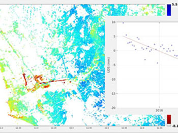
In particular, InSAR is our monitoring solution based on InSAR. InSAR (Interferometric Synthetic Aperture Radar) is
a powerful technique that can remotely measure millimeter-scale deformations over days or years
intervals based on satellite data analysis.
ISO 9001 Certification for platforms for satellite data processing and delivery.
Platform features
We support the customer in all remote sensing life cycle phases (requirements analysis and definition,
design, implementation and validation).
Our unique automatic data processing and workflow allow us to provide cost effective solution for a wide
range of applications.
Data Processing
We use different techniques for a state of art satellite data processing.
Titan4 is built to make your life easier. Both if you are an InSar expert or you don't have any background,
within a few clicks you will be able to setup your processings.
Scalable
Our architecture is fully scalable and built in the cloud, we have no limit.
Any script or tailored processing step will be plug & play.
Fast
Drop you insar processing time from days or weeks to hours with just few clicks.
Automated
The platform has fully automated satellite image data processing and data fusion capabilities.
Accurate
Oversampling and data fusion of high resolution images from different satellites improve the analysis' accuracy.
Cost-effective
Today Earth Observation is very costly, there is no real "industrial processing" of this data and the measurements are all very manual. Our automated platform allows to cut down these costs.
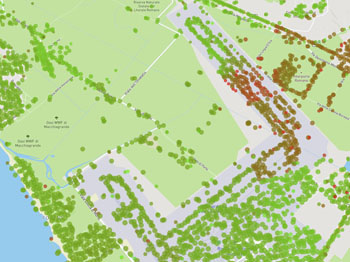
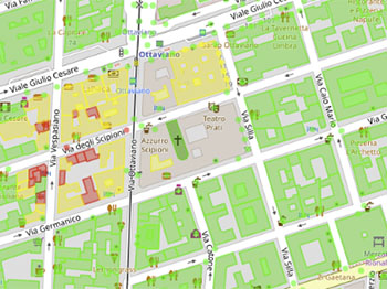
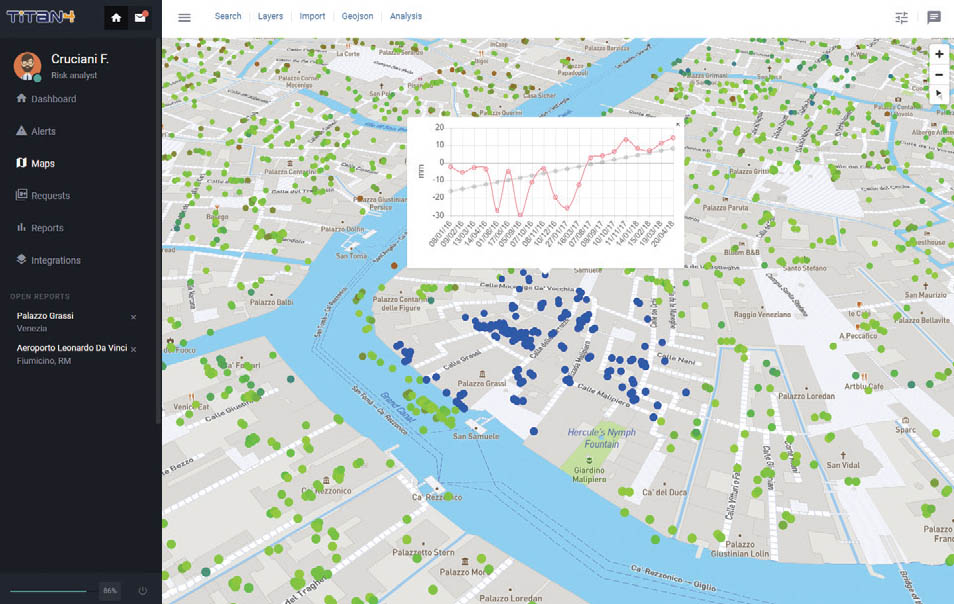
Rich dashboards allow you to better analyze the results.
Visualizing millions of points and analytical data from the browser will help you to extract the most from
our data.
The service can also be requested and consumed through a simple and well-documented REST API.
We can output our result in all standard formats and automatically generate map layers ready to display in
your UI.
Leveraging satellite data for monitoring railway and road assets is integral to assessing ground stability and identifying potential unexpected behaviors. Additionally, monitoring bridges, viaducts, and their surroundings using satellite technology aids in the prompt detection of land deformation that may impact critical assets.
Energy and Utilities
Employing satellite data for monitoring power generators, infrastructure, dams, ducts, and docks is crucial for effective asset management. This integrated approach not only enhances asset management but also provides advanced alerting capabilities for security threats, ensuring a comprehensive and data-driven surveillance system.
Insurance
Utilize satellite data to conduct a thorough risk assessment of any asset, including buildings and infrastructure, for insurance purposes and asset evaluation. Leverage this technology to provide valuable support in the assessment of compensation claims, enhancing the precision and efficiency of the evaluation process.
Construction and Real Estate
Applying satellite data to conduct a comprehensive risk assessment for any construction site or asset, encompassing monitoring and property management. Employ this technology to track worksite progress effectively and identify potential security threats, ensuring a robust and data-informed approach to surveillance and risk mitigation.
Heritage
Utilizing satellite data for the surveillance of historical and natural sites of cultural significance is paramount for effective preservation.
Integrating satellite insights not only advances maintenance practices but also enhances the overall safety and protection of our cultural heritage.
Mining
Exploiting satellite data for monitoring mining operations is essential to evaluate ground stability, detect potential unexpected behavior, and track both operational progress and security measures effectively.
Space data contributes to proactive decision-making for optimal resource management.
Telecommunication
Using effectively satellite data for monitoring telecom infrastructures is crucial for assessing ground stability and identifying potential risks to the stability of network. This approach helps to promptly detect any movements that could impact the efficiency of the tower or antenna structure.
Oil and Gas
Leverage satellite data for monitoring critical assets in the oil and gas sector, providing a comprehensive risk assessment for effective predictive maintenance management.
Enhance the monitoring of pipeline security and facility safety with space data.
Water Service
Space data capacity to monitor extensive areas with high accuracy renders it a potent tool for diverse applications in water management strategies, spanning from the design phase through construction, operation, and maintenance.
About us
Our multi-disciplinary team will follow you throughout the whole process.
We have +50 combined years of experience in aerospace, earth observation, computer science and AI.
Supported by
Awards
Request a demo or contact us
The team counts more than 10 professionals, we are ready to help you.